
OBJECTIVES & PRIORITIES
FLOODPLAIN MANAGEMENT IMAGES
Mission: Effectively promote and maintain a high level of economic welfare and quality of life in Aurora through the floodplain management program.
Goals: Effectively promote citizens, businesses, and roadway users with exceptional quality floodplain management (taken from the Public Works Department website "Goals").
The Floodplain Administration Program is responsible for tracking floodplain revisions, reviewing pond certifications, issuing, reviewing, and tracking elevation certificates, providing flood response assistance, and verifying rating systems.

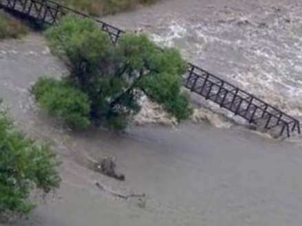

2013 Aurora Flood Report, Courtesy of Marla Keown, Aurora Sentinel
2013 Aurora Flood Report, Courtesy of Scripps Media, 2013
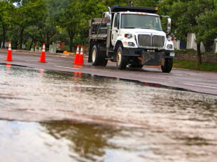
2013 Aurora Flood Report, Courtesy of Marla Keown, Aurora Sentinel
2013 Aurora Flood Report, Courtesy of Marla Keown, Aurora Sentinel
1 - 4
<
>
FLOODPLAIN ADMIN PROGRAM ELEMENT GAPS
To access the full Gap Analysis Technical Memo, please click here. Gaps identified in Phase I and Phase II for the Floodplain Administration Program are listed below.
FLOODPLAIN ADMINISTRATION PATH FORWARD:
• Develop an electronic tracking and filing process for CLOMR and LOMR using GIS and AMANDA as appropriate. Include logging of effective notice and effective dates.
• Complete the data record by scanning all pre-1998 documents such as drainage studies.
• Refine the Certificate of Occupancy process to ensure that pond certifications are done prior to issuance of C.O.
• Develop an electronic process for processing and documenting elevation certificates.
• Improve access to existing documents on individual properties by making changes to the City’s website that make locating documents easier.
• Review FEMA’s National Flood Hazard layer to confirm that all data for Aurora is included and is up to date.
• Identify and incorporate institutional knowledge such that there is a succession process for continuity of the program when staff changes.
• Establish an easy way to get FEMA information.
• Consistently log (and consider developing a process to consistently log) LOMC (Letter of Map Change) effective notices and dates into AMANDA.
• Ensure the successful integration of city-wide Aurora coverage into the National Flood Hazard Layer.
• Convert the floodplain determination and tracking process to an electronic process (currently written/manual). Use the City’s GIS system to document LOMRs or CLOMR. Implement map-based lookup and tracking of floodplain changes in GIS. Document in GIS any pending floodplain changes. Convert the data tracking and documentation to a digital process, perhaps using GIS as noted above, in conjunction with AMANDA.
• Evaluate and change the process for issuing a Certificate of Occupancy with regard to pond certifications to ensure that the process is consistently followed regardless of circumstance.
• Store electronic copies of Elevations Certificates in AMANDA and linked to GIS.
• Improve access to historic documents on the City's website.
• Scan and store documents that were completed prior to 1998 in an electronic database.
FLOODPLAIN ADMIN FUNCTION MATRIX
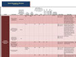
FLOODPLAIN ADMINISTRATION FUNCTION MATRIX & PROGRAM ELEMENT DETAILS
Identifies functions, responsible parties, gaps, and overlaps in the Floodplain Administration Program Element.
