
OBJECTIVES & PRIORITIES
AURORA DATA SYSTEMS
Mission: The Data Management Program Element tracks stormwater asset data in GIS, maintains conditions assessment data in INFOR, maintains storage of other stormwater documents, tracks CIP Prioritization data, and maintains database of work orders and inspection reports.
Goals: The Data Management group should work closely with UDFCD for master GIS and data maps because UDFCD has done a significant amount of GIS and layer planning work that may be beneficial to the City of Aurora, and the City of Aurora may have layers that would benefit current UDFCD efforts.
DATA MGMT PROGRAM ELEMENT GAPS
To access the full Gap Analysis Technical Memo, please click here. Gaps identified in Phase I and Phase II for the Data Management Program are listed below.
DATA MANAGEMENT PATH FORWARD:
• Incorporate a basin connectivity aspect to GIS information so that conditions within each basin can be correlated with other parts of the basin.
• Provide training with regard to what systems perform what functions and store what data. Similarly, define a well-defined structure for each system and how each system relates to one another.
• Consider and evaluate the options for providing one data management system that holds all stormwater infrastructure information and offers central storage and sharing capability.
• Evaluate assets that exist within the City GIS versus actual assets to close gaps.
• Begin to require as-built data and attempt to build a system of as-built data for existing structures.
• Complete a QC review of all of the GIS data to see what is missing, inappropriately cataloged, stored incorrectly, etc.
• Add design storm frequency data to pipes in GIS.
• Formulate a process for consistent storage of data and reports.
• Assign an asset number to all agreements.
• Define a process for tracking permits and inspections to ensure consistency and follow-through, especially with multiple filings.
• Address items that are not currently in GIS:
- Complete inventory of stormwater assets (public and private); older Aurora infrastructure; drop structures; design storm (do not need flow rate); elevations for existing stormwater assets; H&H; as-builts; old stormwater data; development agreements and requirements; easements; annexation agreements; development drainage reports.
• Mirror UDFCD GIS map within Aurora GIS:
- Coordinate regularly with UDFCD to make sure that both agencies are not doing the same thing.
- Ensure consistent naming conventions.
- Aurora’s systems should link to or reference UDFCD information to prevent duplication.
• Work to eliminate overlap in applications to reduce staff confusion.
DATA MGMT FUNCTION MATRIX
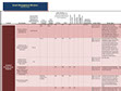
DATA MGMT FUNCTION MATRIX & PROGRAM ELEMENT DETAILS
Identifies functions, responsible parties, gaps, and overlaps in the Data Management Program Element.
ORACLE
The Oracle database is the official sources of Aurora’s records and includes most documents of record.
Features of Oracle include checking documents in and out, manually-assigned metadata, search system, and system-assigned metadata. The keyword search is available to search document summaries, and Aurora can update records with spatial data but needs keys on both sides to relate the GIS location to the documents.
Document characteristics (core metadata) are assigned when documents are checked in.
There is a retention policy to periodically remove out-of-date documents.
Oracle’s native interface is not user-friendly and is infrequently used, so Aurora IT uses two systems that interface with Oracle, AMANDA and ADAMS.
AMANDA
AMANDA is a system in which a user types in an address or subdivision name and filing, and the system retrieves all documents in the database that are associated with the address or subdivision (master plan documents, civil documents, watersheds, roads, bridges, etc.). When users add new content, Aurora IT checks to see if the necessary attributes exist. If new attributes are necessary, Aurora IT defines new metadata.
“Location Keys” are assigned by the AMANDA system as a means of spatial/geographical reference. The location key correlates with GIS documents. A hierarchy of geographical/spatial keys exists: case numbers from subdivisions, master plans, quarter sections, addresses, intersections (for signage) parcels, and more. It is indexed by quarter sections. Street addresses are the best way of targeting a specific location. Ninety percent of documents are identified by address points, some by parcel information. Addresses have an identification (ID) and a key to match the GIS map for addresses, subdivisions, site plans and master plans. AMANDA has an advanced search capability, such as searching nearby and/or vertically overlapping layers from the one that was tagged for additional information.
Once a document is checked into Oracle, it has a user resource link (URL), which AMANDA uses to integrate with permits and licenses. AMANDA keeps a link to the URL of record in Oracle.
AMANDA does not hold documents but holds database records and links to where the document is stored in Oracle.
AMANDA is primarily used for taxes, licenses, permitting and the workflow process for business documents, e.g., liquor licenses.
The public cannot directly access documents in Oracle but can access a subset of documents defined as public through the www.auroragov.org records search box. Outside vendors also cannot access the database. Aurora uses a web service layer for external access to public records.
ADAMS
ADAMS allows document entry into and viewing of the Oracle database. A user types in a geographic location and the system displays relevant documents.
Searches from other metadata can also be done from ADAMS, including searches by keyword and document type.
SHAREPOINT
Aurora also has huge SharePoint system (including PrairieNet and CPDNet) for project management and in-progress working documents.
Once per quarter, SharePoint documents are manually migrated into the Oracle system, and old documents are archived.
GIPSE
GIPSE is an internal application that allows a user to choose an area on a map in GIS to select all “keys” within that area and return documents from Oracle. It has a multi-location select feature, and different keys can retrieve the same documents.
The intent of this system is to make documents and GIS data discoverable for non-GIS personnel.
While it is probably the most used internal tool, the out-of-the-box ADF user interface (UI) isn’t the friendliest, as it requires a lot of “clicks.”
EADOCS
This system is used for management of current projects.
This externally facing system allows contractors to access and contribute content directly to the system.
Implementation is outside of the Aurora firewall/systems
Most of the content in this system is transferred to CPDNet as projects are completed. Migration is done manually as there is no automated or standardized process to transfer content.
HANSEN
Aurora currently uses Hansen for stormwater (and other) asset management
Aurora Water uses Hansen, but Public Works Facilities uses Maximo
Hansen is implemented in-house, and there are three dedicated personnel who can perform system development if necessary.
There are some customizations for environmental use (e.g., acid neutralization, tank detail pages)
Stormwater infrastructure data in Hansen includes basic asset information, including an established stormwater group hierarchy.
Assets follow a naming convention of quarter, section, asset identifier.
The reporting capabilities of Hansen are used, but none of the standardized dashboard capabilities are used. Most current reports are Crystal reports. SWL Server Reporting Services (SSRS) is being used for newer reports.
Hansen does track material costs through warehouse consumables and equipment maintenance hours. There are no CIP costs or disposal costs. There is also no direct correlation to budget costs. However, personnel do run reports that roll up these costs and then manually compare these figures to budgets.
Stormwater pump station data are stored in Hansen and the pumping crews span multiple water groups. There are 3 treatment plants and multiple pumping stations. There are 3 stormwater pumping stations, 1 large and 2 smaller. Data is ultimately centrally recorded for all.
Data flows from GIS into Hansen, and from Hansen to GIS.
Map has fairly standard interface, zoom, pan, select tools, and layer list.
Only the top most layers are available to select features.
The UI involves many clicks and popup windows.
Hansen data and GIS attributes are shown.
Aurora has approximately 260 licenses for Hansen, so any person needing access should be able to be set up without any additional costs.
GIS PLATFORMS
ESRI 10.0 is the provider for all Aurora’s GIS software
ArcGIS Server and Secure Data Exchange store and maintain most of the final/master datasets and utilize Search and Query Language Server 2005
GIS platform contains appx 1300-1400 feature classes
Most systems use ESRI APIs, ADF, JavaScript, and Google Maps API
Preferred technologies are SQL Server, c#, .NET, and js APIs
Assets follow a naming convention of quarter, section, asset identifier.
